
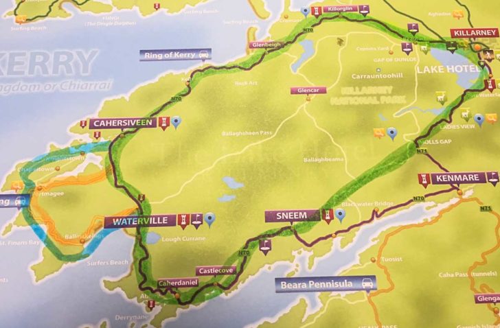
Ring of Kerry Route
The Green Route is the standard Ring of Kerry driven by most Tour Buses and Cars with various interesting stops and amazing scenery.
The Orange loop is the Skellig Ring when there is no Car Ferry October to April with the option to visit Valentia via the bridge at Portmagee.
The Blue route is the most scenic and can be fully enjoyed from April to October via the Car ferry at Renard point and is highly recommended.

Ring of Kerry Map
There is plenty to see beyond the Ring of Kerry route in Green its just to set you going in the right direction.
- Killorglin
- Red Fox Bog Village
- Glenbeigh
- Rossbeigh Beach
- Kells Bay
- Cahersiveen
- Waterville
- Caherdaniel
- Sneem
- Moll’s Gap
- Torc Waterfall
- Killarney
Winter Skellig Ring (no Car ferry) October to April
- Portmagee
- Valentia Island
- Coominaspic pass
- Saint Finian’s bay
- Ballinskelligs
April to October Skellig Ring addition to the Ring of Kerry via the Car ferry at Renard point
- Renard point
- Valentia Car ferry
- Knightstown
- Valentia lighthouse
- Tetrapod trackway
- Valentia Grotto
- Saint Brendan’s Well
- Bray Head walking Trail
- Skellig Experience
- Portmagee
- Coominacpic Pass
- Skellig Chocolate Factory
- Saint Finian’s Bay
- Ballinskelligs


